The purpose of this blog is to document events and compile information related to the Patuxent Branch Trail Extension, T7107.

The Patuxent Branch Trail Extension is a proposed initiative to install a 10 foot wide multi-use pathway along the sewer line adjacent to the Little Patxuent River from downtown Columbia to Savage Park. This 2.8 mile paved trail will travel through the neighborhood of Allview Estates.

The trail extension is part of the Connecting Columbia Action Agenda and is coordinated by the Columbia Association in partnership with the County's Master Bicycle Plan initiative.

Wednesday, April 3, 2013

Another viable alternative?

I received this graphic of an alternative to the proposed pathway in my inbox a couple days ago:

Let me see if I can outline its features.
  • Bikers/walkers would travel east from the lakefront area over route 29 using the existing pedestrian bridge.
  • A new pathway would be installed from the east end of the pedestrian bridge south along 29 to the interchange with Brokenland Parkway.
  • The new pathway would travel under Brokenland Parkway and Stevens Forest Road along the east side of the Little Patuxent River.  There is also the option for the path to travel over Stevens Forest Road using a newly constructed pedestrian bike bridge.
  • From there, the path would travel behind the office parks on Brokenland Parkway and connect with the existing trail system to Lake Elkhorn and Savage.  
  • This alternative also shows optional connectors to Stephens Forest Road and Allview Drive in pink.
From what I can tell, this alternative solves the following problems:
  • Lack of clearance for a path to travel under route 29:  this proposal takes users over 29 using the existing pedestrian bridge.
  • Safety concerns for a trail going under Stevens Forest Road:  this alternative includes an optional foot bridge over, instead.
  • Unsuitable conditions for a pathway along the west side of the Little Patuxent River in Allview Estates:  in this proposed location, the path would be installed at a higher elevation and at a greater distance from the river than is possible on the east side, and it would not have to traverse a permanently underwater and highly flood-prone wetland area.
It also addresses the issues of building over the sewer line, reduced privacy for Allview residents living along the river, and potential added crime and traffic to an otherwise quiet neighborhood.

A note about the optional connectors in pink:  the one shown at the end of Allview Drive (marked dead end) likely requires traversing private property, so I'm not convinced that is even an option.  Nevertheless, I appreciate the time and effort put into this alternative!

Edited to add:  here's another graphic that was sent to me of this option.
 

Wednesday, March 27, 2013

Allview Neighbors Have Successful Meeting With County Reps

On Tuesday, March 26th, 2013, at Atholton Elementary School, a public meeting was held for Allview area residents to meet with county representatives to learn a little bit more about the proposed project T7107.  The meeting was attended by County Council representative Jen Terrasa and numerous representatives from Public Works, the Columbia Association, and Planning and Zoning.  I didn't do a formal count, but I would estimate that there were 60-70 Allview area residents in attendance, too.  After a brief introduction of the proposed project, the floor was opened up for residents to speak on the matter and ask questions of the county officials.

Overall, both sides of the issue were quite well represented.  Residents expressed concerns as well as support for the proposed pathway.  I will attempt to summarize the discussion, but feel free to add anything I missed in the comment sections.

Pros:
  • The pathway would provide a link from the Allview area to the existing pathway system throughout Columbia.
  • The pathway would encourage and facilitate active living and provide a viable alternative to driving.
  • Close and direct access to a multi-use pathway has been shown to improve property value.
  • The pathway would improve quality of life for the Allview neighborhood residents.
Cons:
  • Not all residents place the same value on a paved pathway through their neighborhood.  Some moved to Allview to escape these things.
  • FEMA flood zones are being redefined and enlarged on a regular basis, and the entire proposed pathway lies in the existing flood zone.
  • Adding a 2 mile long, 10' wide impervious surface to an existing flood zone would only serve to exacerbate the already serious and severe flooding problems in Allview.
  • Any potential increase in property value due to proximity of a multi-use pathway could be be negated by increased flooding and the associated insurance costs and may actually result in lower home values
  • The Little Patuxent River is a major drainage route for a large portion of Columbia.  For this reason, even as much as 1/2 inch of rain can cause the river to flood its banks causing unsafe conditions for using the path.  Additionally, the maintenance required for a path that sees this level and frequency of flooding is a concern.
  • Erosion is major problem, and the proposed pathway would need to be constructed very close to the riverbank in some areas.
  • The entire area of the proposed pathway is designated by the county as a wetland preservation area.  By definition, a wetland is an area that is frequently/permanently underwater and/or an area where the water table is at or above ground level.  This definition perfectly describes the proposed location of the pathway:  the area is constantly underwater, wet, and swampy.  This type of area does not seem like a suitable location for a pathway designed for recreational use including bicycling and jogging.
  • There may be restrictions prohibiting vehicular use of a path constructed directly above the sewer line, which is the proposed location.  Vehicular use is necessary for path and sewer line maintenance, and an alternative location (not directly over the sewer line) may not be possible due to the adjacent property being privately owned in many areas.
  • The area under route 29 does not meet the minimum standards set forth for a multi-use pathway.  More specifically, there is not the 10 foot minimum ground clearance and there is no option for lowering the ground level, as the water level prevents that.
  • The footpath over route 29 has been cited as unsafe for use by many, but close-by residents worry that the same concerns exist under the Stevens Forest Road overpass.
  • There was a similar project proposed in the early 1980s that failed the feasibility study due to a determination by the county that any structure built spanning the Little Patuxent River downstream of Allview Drive would dam the river creating unsafe conditions.
  • There may be a legal document in existence prohibiting any and all development along the Allview section of the Little Patuxent River.  Details here are pending.
I hope that this accurately and completely represents the discussion from last night.  Overall, the meeting was well attended and informational.  Assuming the proposed project makes the County Executive's proposed budget, the next opportunity to express your opinion for or against the project will be at the County Council meeting on Monday, April 15th at 7pm.

Cheers!

Tuesday, March 12, 2013

Hate to rain on the parade...

...but, Columbia received 0.52 inches of rain as reported by The Weather Channel and accuweather.com.

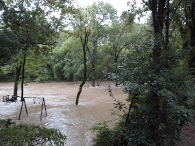
This is what half an inch of rain does to the river:


The water level has risen about 6' to the top of its banks and is almost at path level.  From only 1/2 inch of rain.  And, this seems like a good site for a 10' wide paved path?  It will be covered with water often, and covered with the resulting dirt, sand and debris even more often.  Not to mention how such an impervious surface will only exacerbate the already severe flooding.

Friday, February 22, 2013

New path redundant?

My blogging assistant (code for son) and I spent some time looking at maps of the existing Columbia paths between the lake front area and the Patuxent Branch trail that takes off from Lake Elkhorn.  In comparing the existing paths with the proposed new path, I was reminded just how redundant this new pathway is. 

Have a look at the picture below.  Existing pathways are depicted in green.  The Connecting Columbia initiative proposes the new 2.6 mile extension, shown below in red.  And, the purple shows the much more conservative (and less invasive) approach of connecting existing paths where possible. 
 Am I the only one who notices that nearly half of the proposed path runs directly parallel to an existing pathway along Brokenland Parkway?  Why can't the existing pathway be widened, allowing plenty of room for walkers and cyclists and providing users with direct access to Owen Brown Village Center, the East Columbia Branch Library, and a number of public transit stops? 

Further, I believe installing a path along the purple section between Lake Elkhorn and Cradlerock Drive South is a lower priority part of CA's plan, as is addressing pedestrian and cyclist safety around the intersection of Stephen's Forest Road and Brokenland Parkway heading north to the mall.  The purple approach above meets a number of CA's and Howard County's goals that a path through the back of Allview Estates could never meet.

Sunday, February 10, 2013

Some photos of the proposed site

They say a picture's worth a thousand words.  Here are some photos of the proposed site for the new trail.  These photos document the state of the river during/following heavy rain.  These types of conditions are not isolated to hurricane and tropical storm season- they happen many times a year and can be a result of prolonged heavy rain.
 Imagine the maintenance that would be required on a surface that receives this type of abuse.
 And, imagine the mud and debris that would be left on the path afterwards.
Now imagine the 10 year maintenance costs.  Does this seem like a good site for a path to you?

Friday, February 8, 2013

An alternative to the proposed trail


 ALTERNATIVE
PATUXENT TRAIL EXTENSION

AN ALTERNATIVE TO BUILDING A PATH ON THE EXISTING SEWER LINE BEHIND THE HOMES OF ALLVIEW ESTATES

MATTHEW HOFFMAN
AACA PRESIDENT
(ALLVIEW AREA COMMUNITY ASSOCIATION)

WHY THIS ALTERNATIVE?

  1.  It would be cheaper and easier to build.
  2.  It would be more visible for Columbia.
  3.  It would be less likely to traffic crime.
  4.  It would not infringe upon the privacy of Allview Estates residents.
 Click on photos below to enlarge.


...And Columbia will have a less costly, more visible, direct path that runs adjacent to the lakes, the libraries, and this would already have existing trails leading directly to Columbia villages.

Testimony to the Zoning Board 2/7/13

The following is the testimony that I provided to the Howard County Zoning Board on 2/7/13 during a public meeting.  Our neighborhood was made aware of the meeting via a single sign measuring 8 1/2 x 11 ".  I do not know the exact day the sign was posted, but I believe it was posted no more than a week before the public meeting giving us precious little time to prepare.

Good evening.  My name is Emily Steplowski of 9914 Ferndale Avenue, Columbia, MD 21046.  As a 5 year resident of Allview Estates, I am here to speak in opposition of the proposed Patuxent Branch Trail expansion.

I oppose the trail expansion for four reasons.  The first reason is because it is UNWELCOME.  The residents of Allview have already endured more than three years of nonstop of construction.  The proposal of a new project in a formerly isolated, residential area that has been under constant construction for at least the past 3 years is offensive.  For the recent past, the residents of Allview have dealt with a constant barrage of construction vehicles, construction noise including the use of explosives, and an overwhelming and appalling amount of construction trash that was all related to the new sewer line installation.  I and other residents have removed countless trash bags of construction trash from this area including things like 5 gallon buckets, empty orange spray paint cans and lids, the remnants from sedimentation fencing, and fresh food trash that appeared daily during height the construction.


The second reason I oppose the new footpath is because it is environmentally UNFRIENDLY.  This new construction project will have drastic environmental effects which must be weighed against the potential benefit.  The construction related to the sewer line has already greatly negatively affected the area.  The grade of the land has been drastically altered from what it was when the river was healthy.  There is standing water and flooding year round in places that never used to flood.  The erosion along the river has greatly increased due to the construction, and of course the area of trees and other vegetation that was removed is as wide as a major road.  This precious area was formerly home to much wildlife, which is only now slowly returning to the area.  And, though things are beginning to normalize, the construction along the river has permanently and drastically affected the habitat of this wildlife.  I urge you to consider how yet another construction project will do the same.  And, for what benefit?


Which brings me to the third reason I oppose the new footpath:  it is UNNECESSARY: Columbia does not need any additional footpaths.  The CA maintains over 90 miles of pathways.  In a city that is only 27.7 square miles, that’s 3.25 miles of paths per square mile.  This project is redundant.  Much of the proposed path would travel directly parallel to an already existing walkway along Brokenland Parkway that connects the Stephen’s Forest Road area to Lake Elkhorn and eventually Savage Park.  The money slated for this project would be better spent revitalizing the footbridge over 29 that is already in existence that connects the downtown area to the OM village, which connects to the trail system to Savage.


The final reason that I oppose the trail extension is because the choice of location is UNWISE.  It's apparent that the folks who pitched the idea of installing a footpath through our neighborhood don't spend anytime long that section of the river.  The flooding there is amazing.  It's frequent and widespread and occurs not only as a result of hurricanes and tropical storms, but as a result of simple heavy rain.  This proposed path would be underwater many, many times a season.  It would be a maintenance nightmare.  The temporary bridge that was erected during sewer line construction just downstream of the Allview staging area was washed out numerous times during the duration of that construction alone.


So, in summary, as a resident of Allview Estates, I strongly oppose the trail expansion project because it is unwelcome, environmentally unfriendly, unnecessary and unwise.
Thank you.

Timeline of events related to the Patuxent Branch Trail Expansion

October 2011: The contract for the Columbia Active Transportation Action Agenda project was awarded to Toole Design Group, a nationally-recognized planning and engineering firm specializing in bicycle and pedestrian planning and design. A 16-member citizens’ task force was formed to provide guidance to CA and consultants as they worked to create an active transportation action agenda.

January 2012:  The "Connecting Columbia" initiative was officially born.  An Open House was held by the Columbia Association and was open to the public.

February-March 2012:  The late winter and spring of 2012 was devoted to fieldwork and the development of recommendations.

May 2012:  A second public meeting was held to help draft recommendations and the agenda.

July 2012:  In July 2012, the Connecting Columbia Action Agenda was finalized.  More about the project can be found here.  From their website:

The goal of the Action Agenda is to create a more interconnected bicycling and walking circulation system in Columbia for health, recreational, and transportation purposes. 

Their objectives are:
  • Increase the amount of bicycling and walking throughout Columbia among people of all ages and abilities
  • Improve the safety of the pathway system
  • Increase connectivity to key destinations
  • Make Columbia's pathway network is easy to navigate
  • Coordinate this project with the County's Bicycle Master Plan.
Their desired outcome is for this project include an implementable action agenda that establishes priorities for Columbia bicycling and pedestrian network improvements; identifies implementation projects, including a pathway signage/wayfinding pilot project; creates a series of route maps; recommends partnerships; and identifies responsible parties for the implementation projects.

The project has indeed identified improvement recommendations that they feel will help achieve the goal of increasing the amount of biking and walking in Columbia.  Their improvement recommendations identify the Patuxent Branch Trail Expansion project as #1 priority among the 39 proposed off-road pathway connections.  

February 2013:  A small 8 1/2 x 11" sign was posted on a gate at the end of Allview Drive announcing a Planning Board meeting on 2/7/13 at 7pm.  Despite the short notice, about 20 Allview Estates residents attended the meeting, and several residents expressed extreme opposition to the project.

February 8, 2013:  Laura Boone of Howard County stated that T7107 did pass and it is rated moderate for a feasibility study.  She said many moderate projects get done, and reported the following timetable:  the planning board has to have their recommendations to the County Executive by March 1. County Executive has to have his budget recommendations to the County Council by April 1.  

March 11, 2013:  Executive Ulman's Citizen's Budget hearing was held.  Several people spoke both in favor and in opposition of the project.  The Executive's inclusion of the project in his budget is still pending.

March 26, 2013:   Councilwoman Jen Terrasa held a community meeting for Allview residents to learn more about the project.  In attendance were representatives from Columbia Association, Public Works, and Planning and Zoning and between 60-70 Allview residents.  You can learn more about what was discussed at that meeting here.

April 15, 2013:  If the Executive includes this project in his budget, citizens will again be able to express opinions on the matter at the County Council meeting.